Jimmy Buffett sums it up well in the title of one of my favorite songs: Changes in Latitudes, Changes in Attitudes. But for us to answer this week’s essential question, let’s compare the Bering Sea (50 deg. N latitude-70 deg. N latitude) to the Polynesian Triangle (approximately 20 deg. N latitude-50 deg. S latitude).
 The Bering Sea is said to be one of the most highly productive marine ecosystems on earth and supports the largest commercial fisheries in the world. There are several islands that can be found within the Bering Sea (the Pribilof Islands, Komandorski Islands, Bering Island, St. Lawrence Island, Diomede Islands, King Island, St. Matthew Island, Karaginsky Island and Nunivak Island). The climate of the Bering Sea Islands is influenced by several currents (see image above). These currents, along with the bathometry, make the Bering Sea the jewel it is. Native residents have developed cultures based on marine resources, and today, coastal communities in Western Alaska still rely on the Bering Sea for economic or subsistence use. The mean annual temperature of the Bering Sea Islands is about 35.7° F and there are only two seasons — rainy summers lasting from May to October, and dry winters from November to April. The vegetation is limited to ferns, mosses and grasses, with some creeping willows and small shrubs.
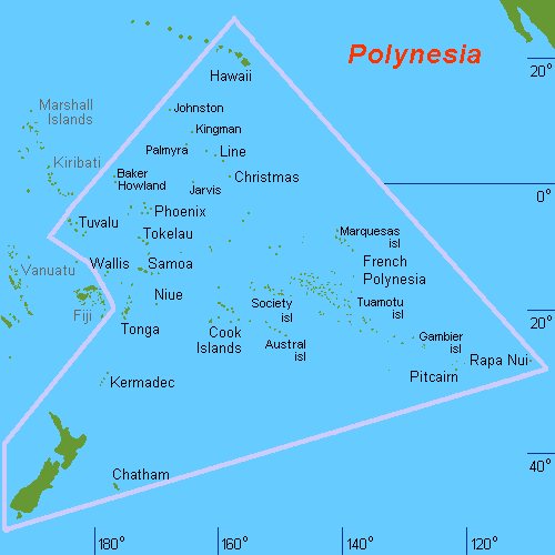
In contrast, the islands of the Polynesian Triangle lie closer to the equator. Steadily blowing trade winds and the South Pacific Gyre allow for relatively constant temperatures throughout the year (70-81 degrees Fahrenheit). The Polynesian Triangle is sometimes referred to as the worlds largest ocean desert because of its lack of marine life and productivity (http://en.wikipedia.org/wiki/South_Pacific_Gyre). Because of living on an island; religion, farming, fishing, weather prediction, out-rigger canoe construction and navigation were highly developed skills in the Polynesian culture. Trading was important and navigators were highly respected and each island maintained a house of navigation with a canoe-building area (http://en.wikipedia.org/wiki/Polynesian_triangle).

Although both examples are of island communities, the climate and cultures vary greatly. This variation is a direct result of the ocean and its currents. Understanding the connection between climate, cultures and oceans is invaluable. Once we become aware of this interconnectedness, we can begin to live more purposefully and make educated choices while doing so.
Images taken from:
